


Project Cartography
Pause And Look At The Map
“I’ve seen men trust a map more than their own eyes. Those are the ones we bury first.”
There is a quiet honesty to this spell that most illusion magic lacks. It does not invent, embellish, or attempt to persuade. It presents information exactly as it was recorded, without refinement or interpretation. In a world still rebuilding its understanding after the Shattering, that restraint carries practical importance. Where other spells attempt to shape perception, Project Cartography is concerned with maintaining fidelity to an existing source.
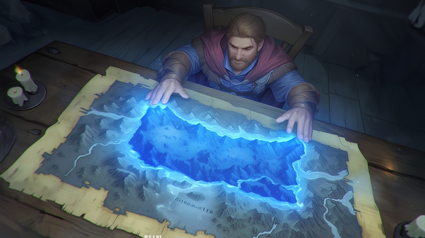
The spell operates on a simple premise. A map is a record, and like any record, it contains both useful information and inherent limitations. When the caster lays a hand upon a map and invokes the spell, that record is translated into a three dimensional projection. The flat representation rises into form, allowing terrain and structure to be observed in a way that more closely reflects physical space.
This transformation does not add new data. It does not extrapolate missing details or resolve ambiguities. It converts what is present into a different format, preserving both accuracy and error in equal measure. Hills become slopes with measurable incline. Rivers gain depth and visible course. Buildings and walls appear as faint but defined structures, providing a clearer sense of layout and relative position.
The projection is limited in scale. It rarely exceeds the size of a small chest and remains anchored to the map from which it is drawn. The caster can examine it from different angles, but the model itself does not expand or change beyond its initial parameters. This constraint reinforces the spell’s purpose as a tool for examination rather than immersion.
The value of the spell lies in how it reveals spatial relationships that are difficult to interpret on a flat surface. Elevation becomes immediately apparent. Narrow passes, steep gradients, and obstructed lines of movement can be identified with greater certainty. Routes that appear efficient in two dimensions may prove impractical when their full structure is considered.
This does not make the projection inherently more accurate than the map. It makes the information easier to evaluate.
Those who rely on the spell understand that a map is not a direct representation of reality. It is a constructed interpretation, shaped by the knowledge, intent, and limitations of the person who created it. Project Cartography does not correct those factors. It presents them more clearly. This is where the spell’s limitations become most significant.
The projection reflects the state of the map at the time it was created, not the current state of the terrain. Roads that have fallen into disuse remain visible. Structures that have collapsed continue to appear intact. Natural features that have shifted or eroded are shown as they were recorded, not as they exist now. The spell does not account for time, and it does not update information.
Because of this, the projection can create a false sense of certainty if used without caution. A path that appears clear may no longer exist. A defensible position may have been altered or compromised. A settlement shown in detail may have changed in ways that are not reflected in the record.
This limitation is not an oversight. It is an inherent aspect of the spell’s design.
Project Cartography does not attempt to bridge the gap between record and reality. It highlights that gap by presenting the record in a form that invites closer scrutiny. Users who treat the projection as a definitive guide rather than a reference risk making decisions based on outdated or incomplete information.
In practice, the spell is most effective when used in conjunction with direct observation. Surveyors and expedition leaders rely on it to plan routes and assess terrain before entering it, but they do not treat it as a substitute for firsthand experience. The projection provides a framework for understanding, which must then be tested against actual conditions.
Archaeomancers have found particular value in this approach. When studying ruins or sites of historical significance, they often work with multiple maps created at different times. By projecting these records, they can compare changes in structure and layout, identifying inconsistencies that may indicate collapse, reconstruction, or misrepresentation. The spell allows them to examine these differences without altering the source material.
This comparative use extends beyond archaeology. Military planners, merchants, and travelers all benefit from the ability to visualize terrain more effectively. In each case, the spell serves as a tool for analysis rather than prediction.
Among cultures that place strong emphasis on environmental awareness, such as the Arin, the spell is treated with practical respect. It is recognized as useful, but not authoritative. Knowledge of terrain is understood to come from direct interaction with the land, not from representation alone. The projection can inform decision making, but it does not replace the need to verify what it shows.
This perspective reflects a broader understanding of the relationship between information and reality. Records are valuable, but they are not complete. They capture a moment, shaped by perspective and circumstance, and remain fixed even as the world changes around them.
Project Cartography makes that fixed nature more apparent.
By converting a map into a three dimensional form, the spell reveals both the strengths and limitations of the original record. It clarifies spatial relationships while preserving inaccuracies. It enhances perception without altering content. In doing so, it reinforces the idea that knowledge must be interpreted with care.
The spell also demonstrates a restrained approach to illusion. It does not attempt to create something new or to alter perception beyond the boundaries of the source material. It works within defined limits and produces consistent results. This predictability has made it a reliable tool in contexts where accuracy is more important than flexibility.
At the same time, the spell does not eliminate uncertainty. It presents information in a clearer form, but it does not resolve the underlying question of whether that information is correct. Users must still evaluate what they see, consider the age and origin of the map, and account for the possibility of change.
This balance between clarity and limitation defines the spell’s role.
Project Cartography does not provide answers. It provides a better way to examine the questions that a map already contains.

“You don’t use a map to know where you are. You use it to understand how wrong you might be.”


Comments